Friday, August 31, 2012

Constructing Paths

I am far from an exhibit fabrication expert, but I did notice a trend at battlefields and historic sites this summer: new rubberized paths.

Not just paths, either. Some places had entire swathes of ground covered in what appeared - to my eye - to be shredded rubber (perhaps recycled tires?) fixed into place in a slightly mounded path. The overall effect was to mimic mulch.

Here's an example from Fredericksburg.
Here's the edge of a patch of rubber that was placed around an exhibit panel near the Burnside Bridge at Manassas.
Walking on it felt spongy and light and even. I would imagine that it would provide good traction and be more accessible to anyone with a physical handicap than the traditional stone dust or asphalt paths. Though it's not immediately apparent from the photographs, if you look at it closely there are quite a few openings between the shreds, which means it probably drains quite well.

Here's the alternative - the badly eroded path up Big Round Top at Gettysburg
Certainly this style of footing wasn't everywhere, but I liked walking on it every time I saw it. It's definitely something I'd think about were I ever to be thinking about an outdoor walk or path.

Does anyone know what the technical term for this material is? Has anyone seen it anywhere but National Parks?

Wednesday, August 29, 2012

Tufts Museum Studies

Last night, I attended the orientation for incoming Tufts University Museum Studies students. I graduated from the program with an MA in History & Museum Studies in May 2012, and have been very involved in promoting it pretty much from day 1. I edit (for a little while longer, anyway) the Tufts Museum Studies blog, have spoken at past info sessions about the program, and last night got the chance to introduce myself to a small group of incoming students as a mentor. I also recently authored the Tufts University overview post on the AAM Emerging Museum Professionals blog.

It's an interesting feeling, being "senior" enough to be considered a mentor, but I really enjoyed interacting with the incoming students. Tufts always gets a great mix of enthusiastic just-out-of-college young people as well as midlife career changers. The mix adds a lot to the program.

I also enjoyed connecting with recent graduates that I was in classes with but haven't touched base with in some time. Some are doing utterly fabulous things in their new institutions, and others have moved on to exciting graduate programs in disciplines like historic preservation, which dovetail nicely with a museum studies certificate. I know networking is often used as a dirty word, but I love it. Museum people are my kind of people, and any excuse to spend more time with them is a welcome one for me!

Monday, August 27, 2012

Where are they now?: Three approaches

One thing that I always appreciated at the various battlefields and museums we visited was when sites told us what happened after the fact for the individuals they talked about in their exhibits or videos. During the trip, we saw three different ways to do that, each of them effective for different reasons.

The first was at Shiloh, whose orientation video was far and away the best that we saw during the entire trip. It integrated first person stories - focusing on specific individuals during the battle - with broader narrative seamlessly, had just the right amount of excitement and seriousness, and was well-edited and well-filmed besides.

After the video but before the credits, each "character" from the film, from Ulysses S. Grant on down to couriers and privates, was given a short biographical slide with a photograph from later in life and a text description of where they went in life. It was great to see, for example, that the young Confederate courier we saw in the film survived the war and returned to the battlefield to help establish it as a National Park many years later. I thought that this style was an effective way of bringing out a personal story and then sharing its ending without lecturing or spending too much time.

The second was at the Museum of the Confederacy in Appomattox, Virginia. It featured two different "continuation" sections, one focused on soldiers, and one focused on civilians. These two sections were in different parts of the exhibit space; the first was in the midst of the space telling about the army and fighting of the war, and the second in the war's aftermath section.

Where are they now? Soldiers Edition.
Where are they now? Civilians Edition.
This method had the benefit of being interactive, and of allowing the visitor a choice as to which soldier or civilian to learn more about. One major problem, however, was that the panels didn't stay turned. They were difficult to turn over in the first place, and unless you held them down, they would snap right back to their top photograph very quickly. This discouraged me after reading two or three stories.

The last way of sharing stories was at the Chancellorsville Visitors Center. It was a small space, with generally outdated exhibits; it looked to my eye as if this particular section was a much more recent installation. It wrapped around an interior U-shaped wall of the entire exhibit space. No matter where you were in the space, one of your walls (to your left or behind you) was covered with stories.


In case you can't read the small label that began the exhibit, it explains: "Green panels in this exhibit identify individuals who survived the war. Black panels denote those who died."


I loved this approach. Several things about it were simple and yet effective.

First, the background color was subtle yet immediately obvious. Choosing a dark green instead of a bolder color meant that you could pick up quickly the information they wanted to convey, but your eye wasn't constantly drawn to the bright colors instead of the black colors. Standing at one end, or stepping back, gave an immediate overall sense of the horrors of war - there were so many black panels.

Second, soldiers and civilians were side by side. Each person had a short story to tell, and the text captured it succinctly. Putting everyone in together emphasized the point that any war, and especially a civil war, takes a terrible toll on a country's civilian population in addition to its soldiers.

Third, it continued throughout the entire gallery. No matter what you were learning about, you had a reference point and a consistent source of interesting information that grounded all the broader exhibits about corps organization and medical care.

Fourth, I even like the somewhat random scattering of these signs. No long, straight line, but a natural jumbling up that allows the eye to move from one panel to the next with interest.

Has anyone ever seen a "where are they now?" installation done? What do you believe are the most effective techniques for doing so?

Friday, August 24, 2012

Day 14: Fort McHenry and Baltimore

We spent the final day of our trip getting to know Baltimore a bit better. Our stated goal was to visit Fort McHenry, in the 200th anniversary year of the War of 1812 (though not of the Battle of Baltimore); after that, we were open.

We started our day, then, with the Fort McHenry National Historic Shrine. We drove into Baltimore in pouring rain, and entered the Visitor Center in the same. The entire building - and its exhibits - had obviously been redone for the anniversary, and it was really quite nice. There were a couple of exhibit pieces I liked a lot, but the real highlight was the new film about the Battle of Baltimore, which was exceptional.

However, the hands-down best part, and one I almost feel guilty for blogging about as the surprise of it was part of its appeal, was the end of the movie. The narrative talked proudly about a unifying national anthem, a chorus swelled in singing...and the entire screen raised up to show a huge window overlooking the fort and the flag waving proudly over it.

I'm not going to lie, I teared up.

Viewing window after the film, though the flag wasn't exactly flying high on this rainy, overcast day.
LOVED this little interactive, about the different ways musicians have interpreted the national anthem over the years.
The fort itself was really neat, and well-explained. It was nice to be able to walk around so much of it, and get a sense for its size and heft.

As we left the Visitor Center, the rain let up, and as we entered the fort, the Park Rangers down there made the decision to swap out the small flag for a larger one (the flags flown over the fort are heavily weather-dependent, and there was a good panel explaining this on the path up). This was the cue for a really remarkable moment - the Rangers asked if anyone wanted to help raise the flag. After an initial moment of awkwardness, people sprinted from across the parade ground to help. It was a simple extraordinary experience that I suppose we would call "participatory" but was also incredibly meaningful - who doesn't want to raise the Star-Spangled Banner over Fort McHenry?

I feel blasphemous saying this, but I almost think this moment would have been ruined by a historical  lecture.
After Fort McHenry, we traveled further downtown to take a look at Camden Yards, which has done a beautiful job of integrating a ballpark right into the heart of a city, using existing historic structures and giving an authentic/throwback feel to the look of the ballpark as well.

We also visited the Baltimore Legends in Sport museum, which was really quite good. For me, a highlight was its use of oral history in its baseball galleries. It seemed like every exhibit case had a video or audio recording of someone connected with past teams, or with a resident who remembered key events in baseball history.

This exhibit about the fire that destroyed the old baseball stadium had both this rather realistic lighting/design treatment as well as audio of Baltimore residents talking about their heartbreak in seeing the flames.
After the Legends Museum was the Babe Ruth Birthplace, which, to be honest, was kind of a letdown. The ticket for both museums was rather pricey, and the birthplace museum was a bit of a jumble. Sometimes I visit museums dedicated to famous individuals and come away thinking I would've really loved them if I'd been a fan of the individual in question. This was one of those museums for me.

They did have a clever way of acknowledging donors, however - one plaque per home run!
With that, we wrapped up our trip, to return back to Boston the next day. It was an intense two weeks that I'll be processing for months and years to come, and added not only to my professional development as a museum professional but also to my understanding of America as a country - it's not often you get to see so many different places in such a short time!

Tuesday, August 21, 2012

Day 13: Fredericksburg, Chancellorsville, and the Wilderness

After all the driving around we'd been doing, the Fredericksburg-Spotsylvania National Military Park seemed like a breeze - after all, the battlefields were so close to each other! We packed up in a slightly more leisurely manner, and arrived at the Fredericksburg Visitors Center. The very helpful park ranger there told us that if we really pushed right on until sunset, we could probably get all four battles done; unfortunately, we'd already made plans for dinner with a friend in Alexandria. We figured he was exaggerating and that we were pros at this after so many car tours.

As if we hadn't learned by now that Park Rangers always know what they're talking about when it comes to these things. By the end of the day, we were sprinting through the Wilderness and had to cancel our original plans to see Spotsylvania Court House, which was our only really big disappointment of the trip.

The Fredericksburg battlefield was probably the most poorly-conserved of all the battlefields we visited on the trip, for the simple and understandable reason that most of the town was destroyed during the battle - and they rebuilt. That said, the key portions were still there, and it was nice to get a good sense of them. The Park Ranger we chatted to about placing the 12th Pennsylvania at Fredericksburg gave us a great overview of the battlefield strategy and why and how it didn't work out. The assaults on Marye's Heights were supposed to be diversionary, but ended up as the primary point of attack after the Union left wasn't reinforced in time to really push at the Confederate lines.

The Sunken Road at Fredericksburg; not quite sunken, but still highly defensible. Marye's Heights up and to the left.
Marye's Heights looking down; you can just barely see the line of the top of the stone wall at the edge of the sunken road.

The 12th Pennsylvania was part of the attack on the Union left. They stepped off from Slaughter Pen farm and marched across open fields, up to a particular railroad bed (that is still there!), then attacked Stonewall Jackson and the Confederate left flank. It was desperate fighting, and the sole Union division of Pennsylvania Reserves was surprisingly successful, breaching the Confederate lines, but they didn't have the reinforcements to follow through. I read in my regimental history while we were driving over to Prospect Hill that in this assault, Company C of the 12th Pennsylvania - which was Richard Gustin's original company, the Troy Guards of Bradford County, that he raised and was voted captain of - suffered 50% casualties.

The top of Prospect Hill, remnants of Confederate trenches.
Slaughter Pen Farm, with Prospect Hill in the distance.
Next up, Chancellorsville. Once again we ignored the Park Ranger's advice at our peril, which was to get lunch before we left Fredericksburg. Turns out there is pretty much nothing past a certain stretch of chain food and strip malls on the road to Chancellorsville. We were already running a bit behind by the time we got to Chancellorsville.

I feel like we didn't spend quite enough time appreciating Lee and Jackson's tactical genius at Chancellorsville, but the visitor center video did a good job of explaining it to us, and also comparing it to Gettysburg, shortly thereafter. The battlefield also had its share of iconic spots.

Site of Lee and Jackson's last meeting, where Lee directed Jackson to march quickly and roll up the Union right flank. He did so with enormous success, and Lee's strategy of splitting his army proved masterful instead of idiotic.
From this spot, and in this direction, Jackson rolled up the Union right flank.
However, Jackson was shot by North Carolina pickets while out scouting his next day's move. He was shot on the small dirt circle that can be seen in the foreground; his horse bolted through the woods and was caught by the road that is still there.
Jackson's arm was amputated, and rests in this peaceful little cemetery today. He died soon thereafter from pneumonia. Sadly, we didn't make it to the Jackson Shrine, aka the house where he died.

The Battle of the Wilderness was next, and here we could clearly see the strategies Ulysses S. Grant had learned in the western theater applied to the eastern theater. The battle itself was more or less a draw; Union forces held their ground, and fought Confederate forces to a standstill, inflicting heavy casualties on the smaller army. The big shift came, however, when instead of retreating to lick his wounds as all previous Union generals had done, Grant took decisive action immediately after the battle, marching on to Spotsylvania Court House and forcing Lee to follow him and fight another bloody battle that he could ill-afford.

The 12th Pennsylvania were once again at the Wilderness, with Richard in command. They were part of Crawford's division here, which found itself far forward of the Union lines in possession of some beautiful high ground. For whatever reason, they were refused reinforcements and had to draw back to Union lines and concede the high ground to the Confederates. Had they stayed, could they have turned the battle? It's tough to say, but apparently Crawford was furious at the time.

Following the path to where Crawford's division held high ground on day one of the Wilderness.
The thing I most remembered about the Wilderness was a particularly nasty episode that happened in thick brush and woods on the Union left. During a day's fighting, the heat from the bullets that went back and forth ignited dry leaves in the brush, and a large section of the forest caught on fire. Wounded men who hadn't been pulled back to their lines died horribly in the fire. I have to say, standing in this particular spot of woods was one of the eeriest moments in all of our visits to battlefields. I had a particular fear of fire as a child, and looking around, thinking about how peaceful and lovely the woods were today, and thinking of them filled with smoke and flame and thick underbrush and the screams of the dying gave me physical chills.

Woods that caught fire during the Wilderness.
At this point, we realized that we had no time to visit the Spotsylvania Court House battlefield, which was the battle almost immediately following the Wilderness, when Lee realized that Grant had moved quickly and decisively to seize the railroad junction at Spotsylvania.

Monday, August 20, 2012

Day 12: Appomattox Court House and the Museum of the Confederacy

We had quite a long drive from the Smokies up through Tennessee, then diagonally across the state of Virginia to get to Appomattox Court House. We had originally hoped to visit Monticello as well, but given the length of the drive and the timing we opted to spend more quality time at Appomattox and not go an hour and a half out of our way to Monticello.

I did not realize that there was quite so much to Appomattox Court House National Historic Park. The small crossroads village had been turned into a sort of open air museum, with houses that replicated the scene (more or less) as it had been when Lee surrendered to Grant at the McLean farmhouse. It was nice, and a bit odd after all our time in remote areas to see a town. In all, it was done to much better effect than Harpers Ferry, which had felt frantic and jumbled and a bit commercial.

The Meeks store, foreground, with the McLean farmhouse back and to the left.
There were a few living history programs going on that day, and one of the volunteers spent quite a while orienting a group of visitors who were headed over to a program. She wanted to make very, very sure that the visitors knew that the living history reenactor wouldn't know that it's 2012, that they shouldn't ask questions about the Superbowl or modern things, that they should understand that he was stuck in 1865. It was a bit overdone; I have mixed feelings about total-immersion living history to begin with, and this reaffirmed many of them. As a theatrical performance it can provide a wonderful window into the past (ie one person shows of famous figures) but as an interactive program it can often frustrate and/or goad visitors.

The McLean farmhouse itself, though not much remains of its original structure, was definitely worth seeing. After seeing Matthews Hill at Manassas, where the war began, what seemed like weeks ago, we were now seeing the room in which it ended.
The McLean farmhouse.

Interior of the parlor. Lee sat at the marble-topped table to the left, Grant at the smaller table to the right.
Since we had no particular interest in seeing a reconstructed town and/or living history programs (living so close, as we do, to one of the best living history museums in the world, Old Sturbridge Village) we finished fairly quickly and headed over to the Museum of the Confederacy, which we'd noticed had just opened a new building right down the street from the park in April 2012.

I have to say, I have never felt outright uncomfortable in a museum before because of its point of view. Perhaps I've been naive until this moment, but I felt that the museum portrayed the Civil War from a bias that was so far from my own beliefs about the conflict that it was nearly hostile.
Entering the exhibit halls, starting with the reasons for war (emphasis on states' rights) and the excitement of going off to war.

It had wonderful collections, and some really engaging exhibits, but the story was decidedly Lost Cause, rather than Preserve the Union. There seemed little attempt to present both sides. Rather, words like "honor" and "romance" were used non-ironically to describe the actions of generals. I have been trying to remember if I noticed any mention at all of slavery. I don't think I did. There may  have been one or two side mentions, but nothing substantive.


In case you can't read it, here is the description of Appomattox and the Confederate decision to surrender:

How To Surrender?
At Appomattox, General Lee ran out of options.

The ranks of his proud army had thinned. The Federal army controlled the Southside Railroad at Appomattox Station, Lee's lifeline to supplies and successful retreat to North Carolina.

The question shifted from how to keep fighting to how to surrender.

Lee's foe offered an honorable answer.
 The exhibits continued on to describe Grant's offering of parole at Appomattox. I'm not sure Grant's decision had much to do with honor, more with practicality. Nothing in this label is wrong. In fact, I think it's a pretty good example of label writing: succinct, descriptive, informative. I just find it a bit uncomfortable to use words like "proud" and "honorable" in this context. Is it just because my point of view is being challenged? Is there actually a troubling characterization here? I've thought about this for some time, and I'm still not sure.

Friday, August 17, 2012

Day 11: Great Smoky Mountain National Park

We didn't do much of anything related to history on the next day, just drove up from Atlanta to visit family in the Knoxville area, then continued east up into Great Smoky Mountain National Park. I'd never visited before, and fell in love.
Our campsite at the Elkmont Campground.

Running right through the campground, a popular spot with tubers and families.
Good morning to the Smokies!
We stopped at the Sugarlands Visitor Center on our way out of the campground the following morning, and they had a small but quite nice natural history museum space focused on the animals of the park.
A little old-fashioned but still holding up well and still very informative.
Sugarlands also had a space outside that intrigued me. Perhaps 20 feet from the center itself, on the way from the parking lot to the building, was this "First Amendment Space."
Small but not tiny; you could easily fit 10-15 people.

The sign, in case you can't read it, says:

"First Amendment" Expression Area

This area has been set aside for individuals or groups exercising their constitutional First Amendment rights. The National Parks Service neither encourages nor discourages, or otherwise endorses, these activities.
I applaud their spirit, if not their unfortunate use of quotation marks.

Sunday, August 12, 2012

Day 10: Lookout Mountain, Chickamauga, Stone Mountain


We were, as it turns out, only about fifteen minutes away from the Lookout Mountain section of the Chattanooga and Chickamauga National Military Park, so we visited that first. The views were absolutely stunning, and though the Chattanooga campaign was a bit difficult to follow, the Lookout Mountain portion was fairly straightforward. The visitors' center had the original large-format painting commissioned by General Joseph Hooker to celebrate his victory at Lookout Mountain in the “Battle Above the Clouds,” and had good interpretation of the same.

Its exhibits were crisp and new and well-done, alternating explanatory text with interesting facts (Rosecrans and Longstreet were roommates at West Point!), and never overwhelming with too much text.
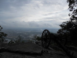
Point Park itself, where the Confederate guns were placed, was stunning. The views over Chattanooga and Tennessee were breathtaking. There was also a neat little exhibit case with Civil War signal corps artifacts and explanatory text – the first time we've seen anything on that part of the army.
Confederate gun emplacement overlooking Chattanooga.
Twisting trails around Point Park.

Seriously, wow.
After Lookout Mountain, we realized we were only a few miles from Rock City, one of the great tourist traps in North America and the location of the climax of Neil Gaiman's novel American Gods. We decided to take a detour, and it was – an experience. Tacky alternated with genuinely lovely. Gaiman's thesis in his novel is that the old world gods came to America with immigrants, and that the holiest places in America are roadside attractions, because they collect that which is uniquely American – a kind of entrepreneurial something-out-of-nothing pop-culture blend. Rock City is certainly the perfect place for all of that to come together.
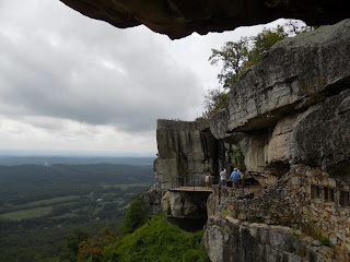
Lover's Leap at Rock City
Next up was the Chickamauga battlefield, the major battle that led up to the siege of Chattanooga. The Confederates won this battle, but ultimately lost the campaign when they failed to successfully siege the Union army at Chattanooga. The battle itself was characterized mostly by staggering failures of communication among the general staff of both sides. Braxton Bragg wrote vague orders and his troops did not attack in time; William Rosecrans pulled a regiment from his right flank to shore up a perceived hole in his left flank. There was no hole, and the removal of a regiment left an actual hole in his right flank at the exact moment James Longstreet arrived to reinforce the Confederate left and made an offensive.

The Union lines crumpled and fled, all except a few brigades under George Thomas's XIIth Corps, who held Snodgrass Hill thanks to determination and to a particular brigade equipped with Spencer repeating rifles, giving Thomas the nickname “The Rock of Chickamauga.” His delaying action allowed Rosecrans and the Army of the Cumberland to retreat safely to Chattanooga. Once the Confederates failed to siege the city, it proved the perfect base of operations for Sherman to march south to Atlanta the following spring.
The slight rise to the left of the photo is where Thomas and his brigades held during the retreat.
The Chickamauga visitors center might have been the nicest we've seen so far. It had a beautiful, welcoming lobby with a big relief map of the battlefield, and some neat exhibits that made good use of artifacts to create scenes. Unfortunately, its orientation video was the worst I have ever seen. I was physically cringing through much of it. It began with a fairly standard framing voiceover leading up to the battle, but the segued into an odd first-person narrative in which two actors playing reminiscing Union and Confederate soldiers (though still wearing their uniforms during what was supposed to be a meeting years after the fact?) chatted about the battle with an odd mix of supposedly personal information and strategic overview. The editing was clumsy at best, and the jaunty way the narrators used slang and referred to actions meant that at the end of 23 minutes I had not the slightest idea what had happened in the battle, and was utterly shocked to hear that the casualties had been so high – in the tens of thousands. It was distasteful and confusing – and as the cherry on top, the Union soldier (or the actor playing him) had a thick Southern accent.
Beautiful, informative entrance hall.

Still from the video; faked Union and Confederate soldiers to the left.
Luckily, there was an old-style electric map in another exhibit that we, along with a dozen other visitors, crowded around in order to understand the order of battle. The driving tour was quick but good, and actually had a nice balance of length and stops. Shiloh had 20 stops, which was wearing; Chickamauga had only 8, but all were important and interesting.

From Chickamauga, we followed in Sherman's footsteps south to Atlanta, then skirted the city to arrive at Stone Mountain, the largest granite outcropping of its kind in the world. Stone Mountain functions as a sort of Confederate shrine: carved onto the mountain is a bas-relief of Jefferson Davis, Robert E. Lee, and Stonewall Jackson. The gardens leading up to the mountain feature small terraces dedicated to each of the Confederate states. (On Mississippi's terrace, the placard noted that among its famous leaders was Jefferson Davis, President of the Confederacy, who “served ably under extremely difficult times.” You don't say.)
Stone Mountain
At the base of the garden were two parks, one dedicated to Valor and the other to Sacrifice, featuring more apologia and some marvelous cognitive dissonance.
"Valor" park.

Many of the sites we've been to have had to handle the difficulty of being in the South while also telling an accurate, whole picture of the war. Stone Mountain was not a museum, nor even a cultural site; it functions today mostly as a family adventure center, with a ropes course and other children's activities. It was definitely the most Southern point of view we've seen so far, and given tomorrow we're turning north for good – it will most likely retain that honor.

Saturday, August 11, 2012

Day 9: Shiloh


I was a little disappointed to find that our route to Shiloh took us through northern Mississippi, rather than across Tennessee, but it was at least a relatively short drive to the battlefield.
Visitors Center at Shiloh National Military Park
The visitor center and bookstore were separate, and the visitor center featured a small exhibit with a couple of neat features, including a set of reproduction Union and Confederate uniforms, child-sized, for kids to put on, and a mirror to look at themselves. The rest of the exhibits were fairly standard. The orientation video, however, was the best we've seen yet, flawlessly integrating first-person stories (as at Manassas) with big-picture quotes from generals and animated battlefield maps to pull the whole story together.
Kids' uniforms at Shiloh
It helps that Shiloh was a basic down-and-back; the Union arrived via riverboat fleet, began to spread out in the hopes of advancing on and seizing the railroad depot in Corinth, MS, and engaged with the Army of the Mississippi under Albert Sidney Johnston. Johnston's army engaged Grant before Grant's second wing had yet arrived, and pushed the Union troops back so effectively that at the end of the first day a message was sent back to Jefferson Davis announcing that the battle was a resounding victory.
Massed Confederate artillery pointed at Union positions within the Hornets Nest
Grant was reinforced by Buell overnight, and used his fresh men to smash the Confederate right, then reinforced his own right to smash the Confederate left, fighting back and regaining the same ground they'd lost the day before and sending the Confederates back to entrench around Corinth. Shiloh was the first battle where Grant began testing out his total war strategy, and was one of the bloodiest of the entire war – the first to really put horrific casualty numbers on newspaper front pages back east.
Shiloh Church, passed twice by the line of battle
The battlefield itself was quite good, and it was easy to pick out major points of engagement (Fraley's Field and the Hornet's Nest among them) and benefited – as did Antietam – from having a fairly simple trajectory over a fairly short period of time.
Fraley's Field, where the battle began at 5am
Looking out and down to Pittsburg Landing, where Union reinforcements under Buell arrived to turn the tide of battle on the second day.
After Shiloh, we pushed on east – through northern Alabama this time, still not through Tennessee – to camp at the foot of Lookout Mountain, on the Tennessee-Georgia border, just outside Chattanooga.

Friday, August 10, 2012

Day 8: Memphis


The next morning we drove up along the western border of Mississippi toward Tennessee to spend the afternoon and evening in Memphis before we began to venture east again. We did only a small amount of tourism in Memphis, seeing at least the outside of the relocated W.C. Handy House (closed and locked despite signs saying it should be open for tours), reading some historical markers on Beale St., and visiting the Cotton Museum.
The oddly-situated and sadly-closed W.C. Handy house.
The Cotton Museum was clearly new and very polished, with some really, really nice bits, and some slightly odd quirks that I will think about and discuss in a future more museum-centric post.
Interior of the Cotton Museum.
That evening we also did a bit of cultural tourism, if you want to call it that, by spending a few hours on Beale St. eating BBQ and taking in the atmosphere of live music and street performances on a Saturday night.
Beale St. on a Saturday Night
We did get in one final museum, and it was an absolute gem. The Schwab/Beale St. Museum is simply a landing area within the Schwab general store, which has been on Beale St. for nearly 150 years. Objects from the store's history were displayed charmingly though with no museum polish to speak of - which is far from a bad thing! There were easily a half-dozen people through the space just in the few minutes before closing.,..on a Saturday night, when bars up and down the street were open! I'll talk more about why I really, really liked this space in a future post.
Looking down from the third floor into th